Alternate names: Tykocin [Pol], Tiktin, טיקטין [Yid], Tykotsin, Тыкоцин [Rus], Tykotzin [Ger], Tikotsin, Tuktin, Tyktin. 53°12' N, 22°47' E, 16 miles WNW of Białystok, 29 miles E of Łomża. 1900 Jewish population: 2,485. Yizkors: Sefer Tiktin (Tel Aviv, 1959); Pinkes Tiktin (Chicago, 1949); and Bóżnice Białostocczyzny (Białystok, 1992). This small, old town in N Poland with 1,800 inhabitants in 1998 on the Narew river is one of the oldest cities in Podlaskie Voivodeship (at least the 11th century). An estimated 3,400 Jewish residents of Tykocin were marched into a nearby forest (Lopochova) and executed by firing squad into mass graves. A memorial exists outside the city. In the Podlaskie Voivodeship since 1999, previously it was part of the Białystok Voivodeship (1975-1998). [July 2009]
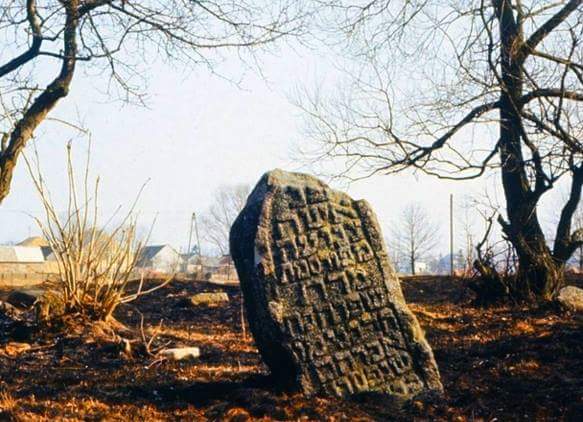
CEMETERY: Located several hundred meters from the synagogue on the way to Tykocin Kiermus and Pentowa, this cemetery existed since 1522. In 1750 Białystok Jews also used this cemetery with characteristic Podlasie gravestones-simple and plain with arched tops. The cemetery was covered with heavy old matzevot and graves of rabbis and gaons. The Nazis destroyed the cemetery using most gravestones and the cemetery wall to build roads. The devastation continued after the war as some Poles used the tombstones for various purposes on their farms. Ten recovered matzevot, used as grinding wheels, are stored in the local museum warehouse. Inscriptions face east. The graves appear randomly located with only the western part having regular rows with walkways. The oldest matzevot date from 1754 and 1792. photos [July 2009]
MASS GRAVE: In the woods in nearby Łopuchowie is a mass grave of Jews from Tykocin, shot in mass executions by the Nazis over two days in August 1941. [July 2009]
ShtetLink 2007 directions, description, and photos: "53°12'19.20"N 22°45'32.16E. Size: 4.5 acres. Number of matzevoth: < 200 (180 counted; 30 with legible inscriptions; sign notes once 2500 graves).Bagnowka.com: Tykocin Gallery (1993, 1996; 2005-2006). As of March 2006, the cemetery is now marked with a sign indicating that this cemetery, established in 1522 with 2500 graves, will be undergoing reconstruction and serve as a place of study and prayer for youth groups (Images 5,6). At present there exists a partial stone wall on the northern border of the cemetery (Image 1) with a simple chain link fence marking the remaining northern, eastern and southern sides (Image 7). The area rapidly covers with low lying vegetation, while various trees and bushes flank the southern side (Image 8). In May 2007, 180 matzevoth were located, most boulder-style, some partially buried in the earth, some covered with moss or lichen. Thirty matzevoth preserve legible inscriptions (Images 9-10). Numerous gentle mounds appear throughout this c. 4.5 acre site, but most mounds are a blanket of grass that covering dung from cows which pasture in the fields open to the west of the cemetery or simply mounds of dirt. The greatest threats to this cemetery are the vegetation and erosion of any remaining inscriptions due to weather conditions." [April 2009]
A map of the synagogue area of the small town shows the Jewish cemetery, which is to the west of the synagogue. Established in 1522, the cemetery has 500 matzevot. Other sources say the 500 gravestones date from 1739.
- REFERENCE: Jewish Bialystok . (See Bialystok) "The 17th-20th century Orthodox cemetery on Pilsudskiego Street is within walking distance of synagogue. Chaim Siemiatycki, writer, was born here in 1908. Tombstones date from 1754 with first burial about 1522. A wall surrounds cemetery from river. Olbracht Gaztold granted the Privilege in 1522 for nine Jewish families to create cemetery. Bialystok Jews were buried here until 1750." [See Abram Gawrin, Dzieje Zydow Tykocina (History of Tykocin Jews ) 1522-1795. Warsaw, 1938]
- REFERENCE: Gruber, Ruth Ellen. Jewish Heritage Travel A Guide to East-Central Europe . New York: John Wiley & Sons, Inc., 1992. p. 69
http://www.igc.apc.org/ddickerson/tykocin.html [October 2000]
MASS GRAVE: In LOPUCHOWO, 4 km SW, was the "5 August 1941 mass murder site of Tykocin Jews. Warsaw Gestapo, commanded by Wolfgang Birkner, Police Units 316 and 309 in cooperation with local "police" forced the Jews to Zawady. Then, near Lopuchowo village in Lopuchowo Forest, 2,000 were murdered. An obelisk marks this site. [Source: Jewish Bialystok by T. Wisniewski]
CEMETERY: Cemetery photos [January 2006]
TYKOCIN: US Commission No. POCE000127
Alternate names: Tiktin in Yiddish and Tyktin in Hebrew. Town is in Wojewodstwo Bialostockie at 53º12 22º47, 30 km from Bialegostoku. The cemetery is in the western part of the town behind the quarter called Kaczorowo between Holendy and Swierczewskiego Streets. 1990 population is 5,000- 25,000 with no Jews.
- Town: Urzad Miasta i Gminy, Tykocin ul. Swierczewskiego 13; tel. 18-16-27.
- Regional: Wojewodski Konserwator Zabytkow, Bialystok, Dojlidy Fabryczne 23, tel. 41-23-32.
- Interested: The local museum staff (in former synagogue buildings) tel. 18-16-13 ul Kozia 2.
The earliest known Jewish community was around 1522. 1921 Jewish population was 1461. Notable individuals there were: Rebeka Tyktin-poetka, pot. XVI w. Euachu Cwi Hirsz HakohºSzimson Kacenel Bogen. The cemetery was established around 1522 with last Orthodox, Conservative or Progressive/Reform burial about 1942. Surrounding villages (no names given) used cemetery. The isolated suburban flat land has a sign in the local language that mentions Jews. Reached by turning off a public road, access is open to all with a broken masonry wall and non-locking gate. Before WWII the size was 2.5 ha. and is now about.2 ha. There are 448 matzevot and 84 concrete supports. Between 100 and 500 gravestones are in original locations and 1-20 not with less than 25% toppled or broken. Stones date from 1791-20th century. The granite, sandstone, slate and concrete; rough stones or boulders, flat shaped stones, finely smoothed and inscribed stones, flat stones with carved relief decoration or double tombstones have Hebrew inscriptions. Some tombstones have traces of painting on their surfaces. There are no known mass graves or structures. The municipality owns site used for Jewish cemetery, agriculture, recreation, and storage. Adjacent properties are commercial or industrial and agricultural. Boundaries are small because of commercial development and lime storage area. Occasionally, organized Jewish group tours, organized individual tours, private visitors and local residents visit. It was vandalized during WWII but not in the last 10 years with no maintenance. Vegetation overgrowth is a seasonal problem, preventing access. Security and incompatible existing development are moderate threats. Weather erosion, vegetation, vandalism and planned development are slight threats.
Tomasz Wisniewski, Bialystok ul. Bema 95/99 tel.212-46 completed the survey on Nov. 26, 1991 after various visits in 1988, 1989 and 1990. He used Patarz punkt 26 and photographs as documentation. Richard Adler, 160 Valley Dr., Ypsilanti, Michigan 48197 was interviewed.
Photos:
http://kehilalinks.jewishgen.org/bialygen/TykocinCem.htm
Photo of Resentative Matzeva, from Fodz