- Alternate names: Radom [Pol, Rus], Радом [Rus], ראדאם [Yid], Rodem, Rudem. 51°25' N, 21°09' E, 58 miles S of Warszawa. Capital of Radom Gubernia, 1867-1917. JOWBR burial list: Jewish Cemetery. This city in central Poland with 227,309 inhabitants is located on the Mleczna River in the Masovian Voivodeship (since 1999) and previously the capital of Radom Voivodeship (1975-1998). Up to WWII, Radom had a significant Jewish population, in 1897, the 11,000 Jews constituted 39%of the total population of 28,700. [June 2009] Yizkors:
- Dos yidishe Radom in khurves; ondenkbukh (Stuttgart, 1948)
- Radom (Tel Aviv, 1961)
- Sefer Radom (Tel Aviv, 1961)
- Radom bi-yeme ha-shoa (Haifa, 1979)
- Toldot kehilat yehude Radom bi-tekufat ha-shoa 1939-1945 (Jerusalem, 1999)
- Pinkas ha-kehilot; entsiklopediya shel ha-yishuvim le-min hivasdam ve-ad le-aher shoat milhemet ha-olam ha-sheniya: Poland vol. 7: Kielce and Lublin (Jerusalem, 1999)
- Local: Prezydent Piasta Radomia, 26-600 Radom, ul. Zeromskiego 53, tel. 2-32-26.
- Regional: Wojewodzki Konserwator Zabytkow, 26-600 Radom, ul. Moniuszki 5a, tel. 2-13-16.
Shtetlink [February 2009]
When Jews first settled in Radom is unclear, but various sources point to 1568 or 1576 when Jewish children are documented. In August 1724, the city extended the "de non tolerandis Judaeis" expelling the Jewish population of Radom, but in 1787, more than 90 Jews lived in New Radomia (Nowego Radomia), dominating the economy of Radom. In 1827, Jews accounted for 23.2% of the population while in 1921, 23,456 Jews were 39.7%. Before WWII, about 30,000 Jews lived there, most dying at Treblinka. Radom ghetto. [June 2009]
CEMETERY:
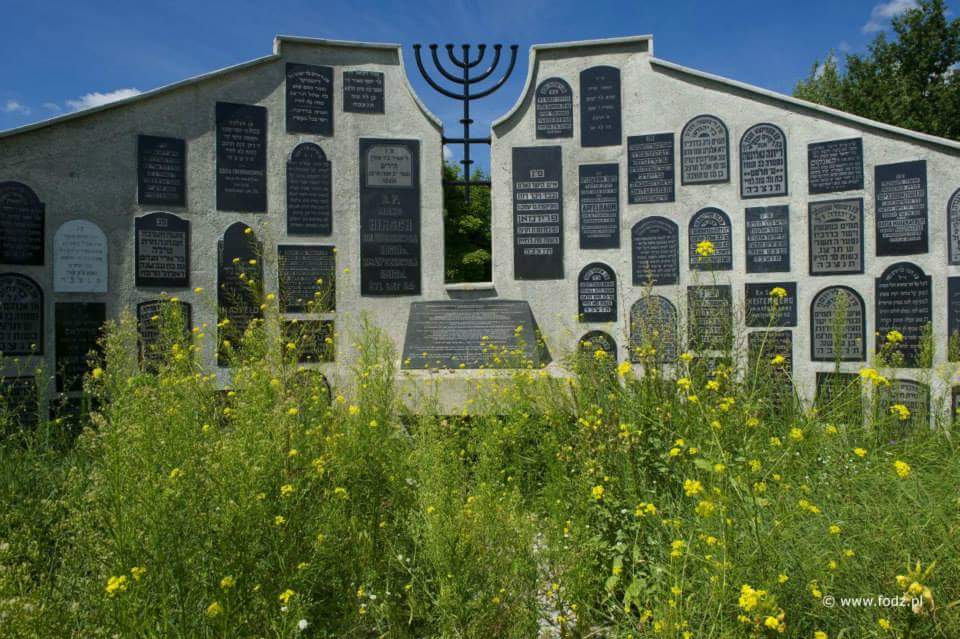
The cemetery located on the outskirts of the street Towarowej was established because of the cholera epidemic of 1831. On November 19, 1837, the cemetery was officially handed over Radom Jews. In 1846, an act was signed to lease of land plots that gradually extended cemetery with further purchases in 1860, 1902 and 1911. During WWII, the Nazis destroyed the cemetery and used almost all gravestones for construction work in the city. The Jewish cemetery was so obliterated that nothing remained although in the 1980s, matzevot fragments were visible in parts of the fenced area. Tomasz Wiśniewski purchased photographs taken by German: In August 1989 the cemetery was landmarked. Subsequently, the area was fenced, an ohel rebuilt and matzevot gathered from various places in the city, not without some resistance. A large group of matzevot at Kamieniarski factory was difficult to recover. A small lapidarium was built. Then, vandals broke ohel windows, damaged some gravestones, and destroyed a plaque commemorating Jewish fighters for Polish independence. In August 2006, the Office for the City of Radom renovated by cutting the grass, replacing the glass in the ohelu, reset the memorial to the Jews fighting for the freedom of Poland, installed a dozen "new" matzevot. Today the cemetery has about 40 matzevot (20 of the left and right of the main avenue) and several dozen pieces of gravestones lying on the ground or forming the lapidarium. The key to the gate of the cemetery is held at a house lived in ul. Twardej 13. Photos. Photos. [June 2009]
Someone volunteered that prisoners will build Holocaust memorial. [July 2009]
JewishGen's Kielce-Radom SIG. [January 2001]
US Commission No. POCE000081
Radom is in Radomskie province at 51º24N 21º10E, 102 km. from Warsaw. Cemetery: Towarowa Street. Present population is over 100,000 with 10-100 Jews.
The earliest known Jewish community was 1576? or 1773. 1921 Jewish population was 23,465 or 39.7%. The Privileges de non-Tolerandis Judaeis granted in 1724. The Orthodox Conservative, and Progressive/Reform cemetery was established in 1837. The last Jewish burial was in 1951. Landmarked: Protection-Wojewodzki Konserwator Zabytkow I Radomin/v.11/. The isolated suburban flat land has no sign or marker. Reached by turning directly off a public road, access is open to all with a continuous masonry wall without gate. The cemetery is 5.0318 sq. meters as before WWII. 1-20 stonesin original position and 100-300 stones not in original location with 25-50% toppled or broken date from 1851. Removed stones are incorporated into roads in the military airport and in the "backyards." The sandstone, finely smoothed and inscribed or flat stones with carved relief decoration have traces of painting on their surfaces and Hebrew and Yiddish inscriptions. The cemetery contains unmarked mass graves. The municipality owns property used as a Jewish cemetery only. Adjacent property is agricultural and residential. The property size compared with pre-WWII is the same. The cemetery is visited occasionally. It was vandalized during World War II, but not in last 10 years. Jewish individuals from abroad and groups from Israel re-erected stones and fixed wall in 1990-1991. The open cemetery has no caretaker. OR There is a regular unpaid caretaker. [sic] Within the limits of the cemetery are no structures. Proposed incompatible development and security (uncontrolled access) are slight threat. Weather erosion, pollution, vegetation, vandalism, and incompatible nearby development are a moderate threat.
Adam Penkalla deceased, completed the survey on August 13, 1991, after visiting the site.
REFERENCE: Independent Frymcie Radymnoer Frauen K.U.V. (New York, N.Y.) Records, 1914-1954. Description: .2 linear ft. Notes: Landsmanshaft founded in 1905 by Jewish immigrants from Radymno, Poland. It was also known as Independent Fremtsche Radimnauer K.U.V. It was dissolved in the 1970s. Cemetery agreements and contracts, 1914-1926; burial permits, 1918-1954; and membership address book. YIVO collections are in Yiddish, Russian, Polish, English, Hebrew, and other European and non-European languages. Location: YIVO Institute for Jewish Research, New York, NY. Control No.: NXYH90-A19
Burial site [Jan 2015]
Photo from FODZ/Facebook [May 2015]