Alternate names: Mstów [Pol], Omstov [Yid], Mstuv [Rus], Omstiv, Amstov, Mstov. 50°50' N, 19°18' E, 8 miles ENE of Częstochowa. Jewish population: about 500. Gmina Mstów is a rural administrative district in Częstochowa County, Silesian Voivodeship in southern Poland with its seat is the village of Mstów, 13 km (8 mi) E of Częstochowa and 68 km (42 mi) N of the regional capital Katowice. The gmina 2006 its total population is 10,189. Gmina Mstów contains the villages and settlements of Brzyszów, Cegielnia, Gąszczyk, Jaskrów, Jaźwiny, Kłobukowice, Kobyłczyce, Krasice, Kuchary, Kuśmierki, Latosówka, Łuszczyn, Małusy Małe, Małusy Wielkie, Mokrzesz, Mstów, Pniaki Mokrzeskie, Rajsko, Siedlec, Srocko, Wancerzów and Zawada.
Normal 0
In 1697, the city had a Baroque synagogue built in place of a pre-existing smaller synagogue. The Jewish community in Mstow became independent at the beginning of the 19th century although previously subject to nearby Janowie kahał. The 1921 census with 740 Jews (37.6%) showed a population decline due to immigration in the 19th and early 20th centuries. After the outbreak of World War II, the Jews were subjected to repression. In the first months of 1940, a ghetto was created in the area of ul. Garncarskiej and ul. Garncarskiejand ul. Koziej. In summer 1942, the ghetto was liquidated and its inhabitants deported to Radomska, where a few months later they went to Treblinka.
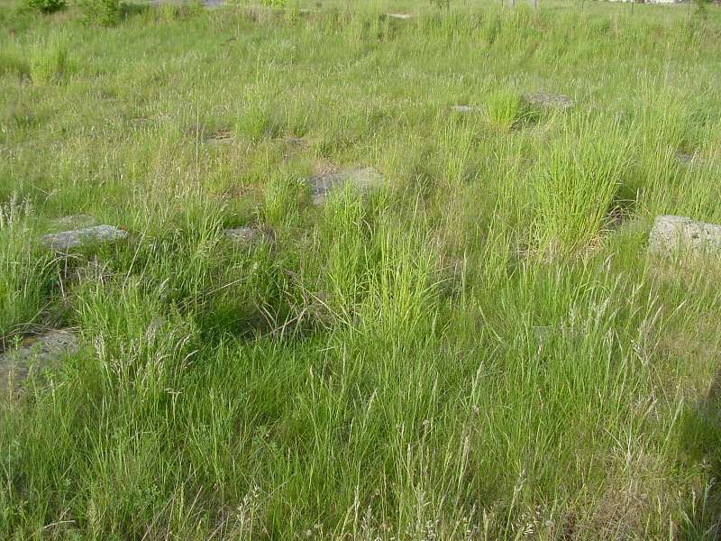
CEMETERY: The cemetery was established in the 19th century on current ul. Kilińskiego. To this day only individual gravestones remain because the cemetery was destroyed during the Holocaust. Klubsch the mayor demolished historic houses on ulica Kościelnej from the market to UL Library. The above-mentioned section of road walkway received the gravestones. Quite a large number of these monuments were dumped in Warcie near the cemetery. [June 2009]
US Commission No AS 159
Mstow is located in Czestochowa at 50º49 19º17, 14 km from Czestochowa. Cemetery location: W from town at Warta river. Present town population is 1,000-5,000 without Jews.
- Town: Urzad Gminy, tel. 5.
- Regional: Wojewodzki Konserwator Zabytkow, Aleksander Brode, 47-217 Czestochowa, ul. Domagelskich 2, tel. 4974.
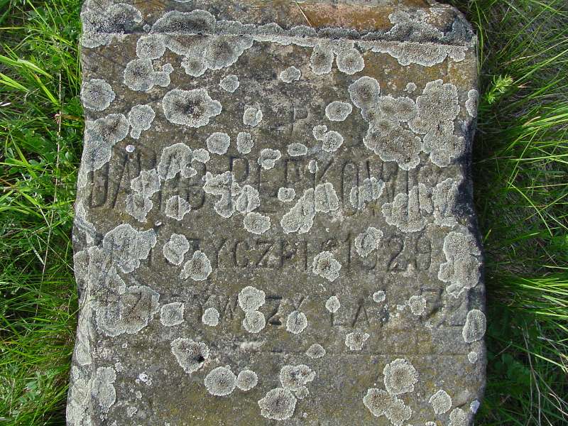
The earliest known Jewish community is second half of 19th century. 1921 Jewish population was 740. The Hasidic Jewish cemetery was established about 1880. The isolated suburban flat land has no sign or marker. Reached by turning directly off a public road, access is open to all without wall or gate (only remnants of stone wall remain.) 20-100 gravestones in the cemetery, none in original locations with more than 75% broken or toppled, date from 19th-20th century. Some removed stones are in Warta river and others throughout the town. The sandstone flat shaped stones and finely smoothed and inscribed stones have Hebrew inscriptions and Polish. No mass graves. The municipality owns property used for recreation. Properties adjacent are commercial/industrial and agricultural. The cemetery boundaries are the same as in 1939. Frequently, local residents visit. The cemetery was vandalized during WWII. There is no care or structures. Jan Pawel Woronczak, Sandomierska St. 21 m. 1, 02-567 Warszawa, tel. 49-54-62 completed survey 29 Nov 1991.
Jan and Jeny Woronczak visited site in 1986; interviews conducted.
UPDATE: Very few stones remain; and none are standing. The cemetery is in an open field, with slightly visible remains of a surrounding wall. A man who lives across the street lights a candle and places it on one of the stones every now and then, in memory. I took photos of all stones with any characters visible (under 10 digital jpgs, about 800K each.) Source: Daniel Kazez on JewishGen Digest. [May 2002]
UPDATE: Burial list [August 2005].