Alternate names: Slavuta and Славута [Ukr, Rus], Slovita and סלאוויטא [Yid], Sławuta [Pol], Slavouta. 50°18' N, 26°52' E, On the Horyn River, 61 miles N of Khmelnytskyy (Proskurov), 35 miles SE of Rivne (Rovno), 13 miles NNE of Izyaslav (Zaslav). Jewish population: 4,891 (in 1897), 5,102 (in 1939)
- JewishGen Ukraine SIG
- Słownik Geograficzny Królestwa Polskiego (1880-1902), X, pp. 793-794: "Sławuta".
- Shtetl Finder (1989), p. 94: "Slovita".
- Encyclopedia of Jewish Life (2001), pp. 1198-99: "Slavuta".
- Wikipedia. [Mar 2014[
- Jewish history and photos. iMar 2014[
2. August 1919, organized by Polish troops, 7 murdered, 3 wounded
3. September 1920, a disorganized partisan band 3 murdered, 3O wounded.
Near former military town: This place called now a Memory Fileld. Jews from Slavuta ghetto was killed at this place at June 25, 1942. After the war commision find there 11 graves. Monument was erected in 1986. Near this place was located german's Grosslazaret 301, a military camp for wounded captives. According to soviet commision in this "hospital" were killed more than 150000 soviet soldiers.
Near sewing factory: More than 300 jewish child were thrown into a well during ghetto liquidation in March 1941. There was a building with basement where were killed old jews and cripples from Annopol Ghetto. Monument was erected in 1990.
SLAVUTA I: US Commission No. UA22190101
Alternate name: Slawuta (Yiddish), Slovita (German) and Slowita (Hungarian.) Slavuta is located in Khmelnitskaya at 50º18 26º52, 80 km from Khmelnitskiy and 56 km from Rovno. The cemetery is located at Oktyabrskaya, St. 56, W. Present town population is 25,001-100,000 with 101-1,000 Jews.
- Town officials: Mayor Dzyun Petr Alekseevich (03842)21359. Local officials: Slavuta Rayispolkom of Rozdobutko Anatoliy Grigorievich.
- Regional: Oblispolkom - Guseynikov Evgeniy Yakovlevich [Phone: (03822)65024]. Oblast Dept. of Culture, Slobodyanyuk Petr Yakovlevich (03822)65025.
- Slavuta Jewish Community, Goshkins David Isaakovich.
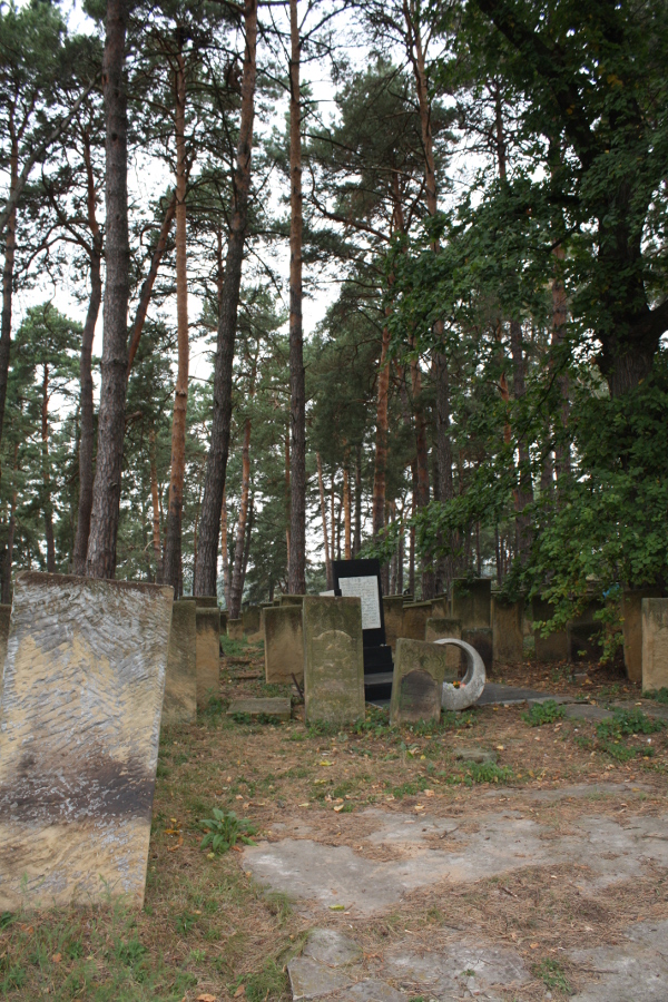
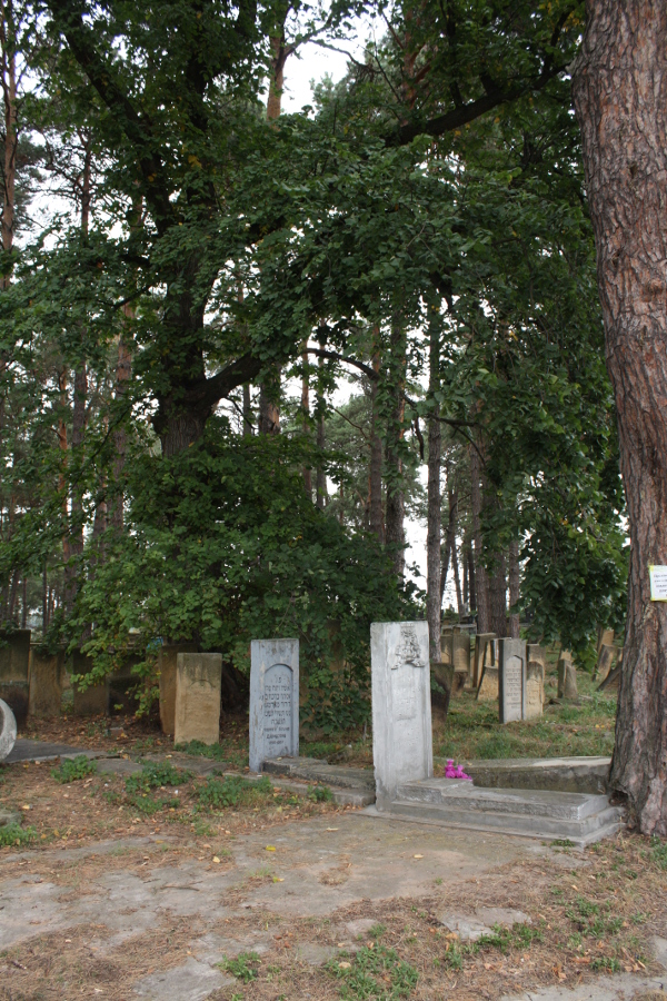
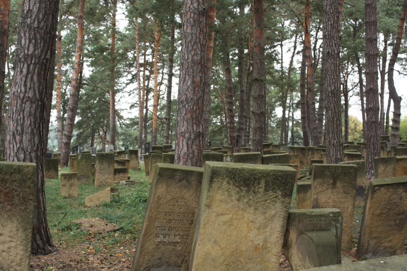
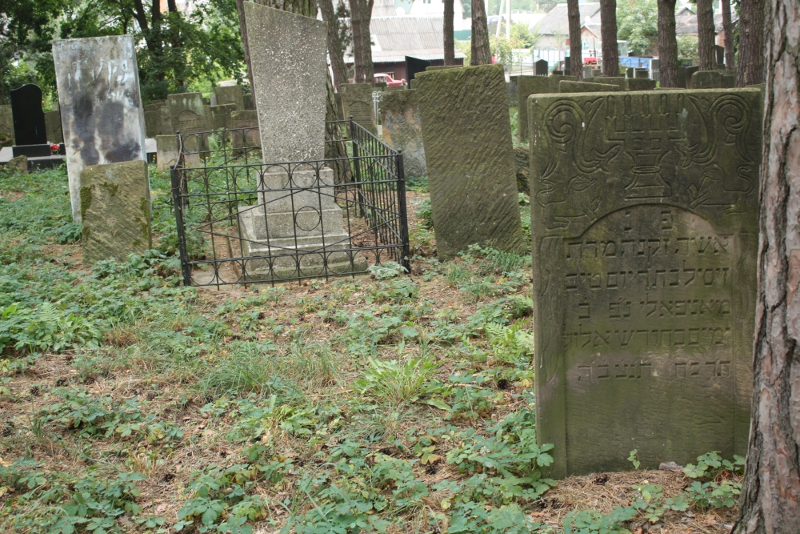
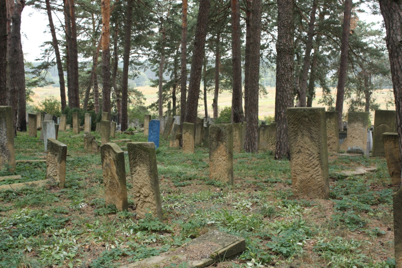
- The earliest known Jewish Community was 17th century. 1926 Jewish population (census) was 12000 but only 4701 in 1939. Effecting Jewish Community were 1918-1920 Civil War Pogroms and 1941-1942 Holocaust. Living here were Tsadic of Hasidic Dynasty Shapiro and Rab Itshak-Gdal Liberzon (1904-1982.) The Jewish cemetery was established in 1902. Buried here areTsadic of Hasidic Dynasty Shapiro and Rab. Itshak-Gdal Liberzon (1904-1982.) The last known Hasidic burial was 1995. The isolated suburban flat land has no sign, but has Jewish symbols on gate or wall. Reached by town street, access is open to all. A continuous fence with non-locking gate surrounds the unlandmarked cemetery. 501 to 5000 stones, all in original location with none toppled or broken, date from 1902. Location of any removed stones is unknown. The cemetery has no special sections. Some tombstones have traces of painting on their surfaces, iron decorations or lettering, with bronze decorations or lettering, other metallic elements, portraits on stones and/or metal fences around graves. The cemetery contains no known mass graves. Municipality owns site used for Jewish cemetery only. Properties adjacent are residential and Catholic cemetery. The cemetery boundaries are unchanged since 1939. The cemetery is visited frequently by organized individual tours and Jewish or non-Jewish private visitors. The cemetery was vandalized prior to World War II. Jewish individuals within country and abroad and Jewish groups within country did re-erection of stones, patched broken stones, cleaned stones, cleared vegetation, fixed wall and fixed gate 1945-48, 1990. Jewish community pays the regular caretaker. Within the limits of the cemetery are an ohel and other structures. Vegetation overgrowth and water drainage are seasonal problems. Moderate threat: uncontrolled access and vegetation. Slight threat: pollution.
- Oks Vladimir Moiseevich of 270065, Odessa, Varnenskaya St. 17D, Apt. 52 [Phone: (0482) 665950] visited site on 3/28/95. Interviewed was Goshkis D.I., Kiperovas M.I. of Slavuta on 3/28/95. Oks completed survey on 04/06/1995.
- SLAVUTA II: US Commission No. UA22190102
- See SALVUTA I for town information. The unlandmarked Hasidic cemetery is located at Revolyutsii st., W, r. Goryn. The isolated urban flat land by water has no sign or marker. Reached by town street, access is open to all. No wall, fence, or gate surrounds the cemetery. 21 to 100 common tombstones, few in original location with more than 75% toppled or broken, date from 19th century. Location of any removed stones is unknown. The cemetery contains no known mass graves. Municipality owns site used for recreational use (park, playground, sports.) Properties adjacent are residential and river Goryn. The cemetery boundaries are smaller now than 1939 because of river Goryn. Local residents visit rarely. The cemetery was vandalized during World War II but not in the last ten years. There is no maintenance. Within the limits of the cemetery are no structures. Vegetation overgrowth is a constant problem, disturbing both graves and stones. Water drainage at the cemetery is a constant problem. Very serious threat: uncontrolled access, vegetation, vandalism and existing nearby development. Moderate threat: weather erosion, pollution and proposed nearby development. See above for surveyor information.
- SLAVUTA III: US Commission No. UA22190501
- See SLAVUTA I for town information.
- The mass grave is located at center, Volodarskogo St. See Slavuta above for town and history information. The Jewish mass grave was dug in 1942. No other towns or village's Jews were murdered at this unlandmarked mass grave. The isolated urban flat land has signs or plaques in local language and Hebrew mentioning Jews and the Holocaust. Reached by town street, access is open to all. A continuous fence with no gate surrounds the mass grave. The approximate size of mass grave is now 0.01 hectares. No stones were removed. Stones date from 1990. Municipality owns site. Properties adjacent are residential. Frequently, organized Jewish group tours or pilgrimage groups and Jewish or non-Jewish private visitors stop. This mass grave has not been vandalized. Authorities clean or clear occasionally. Within the limits of the mass grave are no structures. Slight threat: uncontrolled access. See above for surveyor information.
- SLAVUTA IV: US Commission No. UA22190502
- See SLAVUTA I for town information.
- The mass grave is located at Izyaslav Highway, SW, 500m from military post. The Jewish mass grave was dug in 1942. Jews of Volinaian (15 km away) were murdered at this unlandmarked mass grave. The isolated suburb has signs or plaques in local language and Hebrew mentioning Jews and the Holocaust. Reached by turning directly off a public road, access is open to all. No wall, fence, or gate surrounds the mass grave. The approximate size of mass grave is now 0.01 hectares. No stones were removed. Common tombstones date from 1990. The site contains marked mass graves. Municipality owns site used for mass burial site. Properties adjacent are agricultural. Organized individual tours and Jewish or non-Jewish private visitors frequently visit. This mass grave has not been vandalized. Authorities clean or clear occasionally. Within the limits of the mass grave are no structures. Seasonal problems are vegetation overgrowth and water drainage. Moderate threat: vgetation. Slight threat: uncontrolled access, weather erosion and pollution. See above for survey information.
[UPDATE] Jewish Cemetery photo [December 2017]
[UPDATE] Photos by Peter Lyons [October 2018]